

Death Valley 2-Day Excursion
Life
& Lore Abound on Death Valley 2-Day Excursion
Text
& Photos by Sandra Scott
I love Las Vegas! I love everything about it: the glitz, the glitter,
the
gambling, the good food. But, after a few days I start to suffer from
sensory overload. I need to clean my brain, refresh my spirit, and get
a
grip on reality. The solution - head for the desert!
There are many great side trips from Vegas but, without a doubt, a two-day
circuit through Death Valley is one of the most unforgettable. If your
idea of Death Valley is one of a vast nothingness baking in the shimmering
heat, then you are in for a big surprise. Death Valley does hold the record
as the hottest place in the United States, and it is the lowest point
in the Western Hemisphere; but, it is also a place where it often snows
and there are some very high peaks.
Contrary to the dire sounding name, Death Valley is a thriving ecosystem that is home to more than 900 species of plants, a wide variety of wildlife and many unique, natural and man-made wonders. It is a place that exemplifies the quintessence of America's frontier spirit of survival. Set aside your preconceptions, open your mind to the subtle beauty inherent in desert terrain and prepare yourself for an unforgettable adventure.
Day One
Stock up on bottles of water, pack a lunch, don your sunglasses, put on
your walking shoes, bring your bathing suit and don't forget your spirit
of adventure. Head south out of Las Vegas on Interstate 15; at the Route160
intersection turn west, and let the adventure begin.
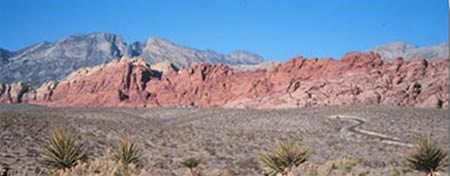
The first leg of the trip traverses the southern portion of Red Rock
Canyon; resist the temptation to stop and explore. Red Rock Canyon
Recreation Area, a beautiful and diverse area, is a wondrous day-trip
unto itself.
During the first 50 miles, notice the contrast between Las Vegas and
surrounding desert, remembering that 50 years ago Las Vegas was a
never-heard-of stop on a long, lonesome desert highway. For the next 50
or so miles, feel yourself unwind; tune into the ever-changing desert
scenery. The landscape is the first breathtaking feature noticed by
visitors. Rock layers, visible throughout Death Valley, reveal a nearly
complete record of the Earth's geologic past.
Be on the lookout for wild burros. They are descendants of those that
got away from early pioneers. Because they do well in a desert habitat,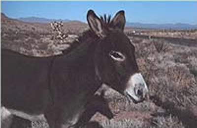 the burros carved out aniche in Death Valley. The Wild Horse and Burro
Act of 1971 protects them; however, they compete with the bighorns and
other native species, foul water sources, overgraze and trample the undergrowth.
To protect the fragile desert ecosystem, the Bureau of Land Management
controls the population by capturing some and offering them for adoption.
the burros carved out aniche in Death Valley. The Wild Horse and Burro
Act of 1971 protects them; however, they compete with the bighorns and
other native species, foul water sources, overgraze and trample the undergrowth.
To protect the fragile desert ecosystem, the Bureau of Land Management
controls the population by capturing some and offering them for adoption.
The Mojave Yucca, easily identifiable by it's starburst of two-foot long
leaves, provided food for Native Americans, who also used the fibrous
leaves to make cloth and sandals. During World War II, this plant was
used in the manufacture of burlap.
This stretch of road could be termed "The Way of Lost Hope and Forgotten Dreams," for it roughly follows the Old Spanish Trail forged by Spanish explorers in 1830. A decade later it was an important route between Mormon settlements in Utah and California.
The '49ers used this trail as a winter route to the gold fields in
California. By the time they reached Death Valley, reality had set in,
and
then things got worse. Shortly after leaving the Red Rock area, the road
rises to an elevation of 5,493 feet.
The cottonwoods, juniper trees and pinyon pines in Mountain Spring Pass were evidence to the early travelers that here was a source of water. The white, powdery film on the juniper berries is the yeast that is essential in the making of sourdough bread, a staple of the early miners. The nuts of the pinyon pines were an important food source for Native Americans.
Eighteen miles later turn west toward Tecopa; about 5 miles down the
 road,
make the turn for Cathedral Canyon. A short distance down this side road
is one-man's way of coping with his young daughter's untimely death.
road,
make the turn for Cathedral Canyon. A short distance down this side road
is one-man's way of coping with his young daughter's untimely death.
Rolland Wiley spent more than $1 million turning this mud wash into one of Death Valley's more incongruous sites. Dedicated to peace and harmony among all of God's creatures, the half-mile meandering canyon is decorated with famous quotes, stained glass, waterfalls, pictures, benches and statuary. In the quiet of the desert, one can feel the depth of his loss.
Wiley died in 1994, so the area is in dire need of refurbishing.
This little side trip takes about 30 minutes. Return to the main highway
and continue west. Large clusters of Mesquite trees along the road are
another indication that water is close to the surface. The trees look
more
like huge bushes because the trunk and lower portions of these trees have
been buried by wind-blown sand leaving only the tips of the branches visible.
About 15 miles past the California border, the highway crosses the Nopah
Mountains at Emigrant Pass. Park the car, walk about 300 yards
to the ridge and look back at the valley to see the ruts carved into the
floor of the desert by hundreds of pioneer wagons more than 150 years
ago. By the time the pioneers had reached this point, their initial enthusiasm
had waned; many questioned the wisdom of the adventure, others prayed
to just survive.
Another 10 miles down the road, take the turnoff to discover anotherone of the desert's little secrets. China Ranch is a working family farm set in a lush piece of greenery amidst the forbidding Mojave Desert -- a classic desert fantasy. The Old Spanish Trail is within easy walking distance, as is the historic Tonopah & Tidewater Railroad.
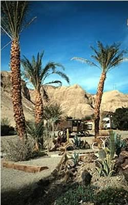
Visitors can hike to nearby old mines, or take an interpretive guided nature walk (make reservations at 760 852 4415). You'll learn about geology, botany, birds, early man in the area, the Old Spanish Trail and much more. The ranch's gift shop sells a variety of items including packaged dates, date shakes, date-nut bread, jams, post cards and unique hand crafted gifts. This detour takes between 45 minutes and two hours.
Back out on the main road, it quickly merges into Route 127; continue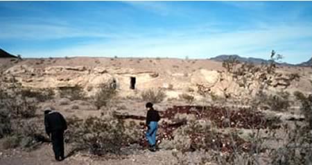
about 10 miles to the intersection of Highways 178 and 127 at the townof
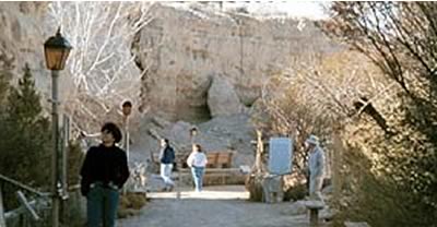
Shoshone. Near the intersection, the dirt road to the left will take you
about a quarter a mile to the Cave Houses. In the early part of the century,
settlers and prospectors carved their homes into the soft sediment. The
stillness belies the beehive of activity that once encompassed the area.
Back on the highway, two miles down the road, turn left onto Highway
178; 5 miles later you will officially be in Death Valley National Park.
Eighteen miles down the road is a photo opportunity. Look for Skull Rock
on the left. Use your imagination!
A few miles later, the road dips below sea level for the rest of the
day's
journey. The long, wide valley was once an ancient lake, 100 miles long
and 600 feet deep, called Lake Manly. About 50 miles from the park
entrance is the lowest elevation in the United States, and indeed in the
Western Hemisphere.
Park the car and walk out onto the salt flats. A photo at the sign
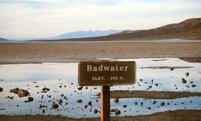 indicating
the elevation is compulsory! A salt-crusted pool of water containing four
to five times the salt content of the ocean, Badwater is 282 feet below
sea level. Only by gazing up at the sign high on the side of the mountain
that reads "sea level" can one truly comprehend the depth.
indicating
the elevation is compulsory! A salt-crusted pool of water containing four
to five times the salt content of the ocean, Badwater is 282 feet below
sea level. Only by gazing up at the sign high on the side of the mountain
that reads "sea level" can one truly comprehend the depth.
Even here plants such as the Desert Holly and Pickleweed thrive. Badwater never dries out completely, and even manages to support a unique species of fish - the Death Valley Pupfish, a small bluish, creature that has evolved to survive in the hot saline conditions.
About 20 miles from Badwater, at Furnace Creek Inn and Resort (760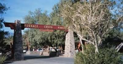 786 2345), there are three options for over-nighting: the recentlyrenovated
up-scale inn, the family orientated ranch situated around a 16-hole golf
course or the campground nearby something for every price class.
786 2345), there are three options for over-nighting: the recentlyrenovated
up-scale inn, the family orientated ranch situated around a 16-hole golf
course or the campground nearby something for every price class.
Now the evening fun begins! There are several options, and it is best
to
organize your next 24 hours, and make any necessary reservations. Consider
a moonlight horse ride, a hayride or a free show at the visitor center
that explains various historical and geological aspects of the park. Death
Valley's location far from city lights makes it an ideal location for
the street-side astronomers who are often set up outside the visitor center.
So much to do, so little time!
Day 2
After a refreshing night's sleep try a sunrise horse ride or an early
morning hike though one of the many nearby canyons, followed by a hearty
breakfast. You may prefer a round of golf at the lowest golf course in
the world, a quick dip in the pool fed by natural warm springs or a leisurely
game of tennis. Before long it will be time to have lunch and hit the
road again.
Make sure to squeeze in a visit to the Borax Museum. It is pictorial
 history
and showcase of artifacts from the past, such as antique stagecoaches,
mining tools and a railroad steam locomotive from the Death Valley Railroad.
Head southeast on Route 190 to Zabriskie Point for a panorama of undulating
gullies and mud hills. The flat salt plains on the valley floor are visible
in the distance. It will take about 30 minutes to drive up, look around
and return.
history
and showcase of artifacts from the past, such as antique stagecoaches,
mining tools and a railroad steam locomotive from the Death Valley Railroad.
Head southeast on Route 190 to Zabriskie Point for a panorama of undulating
gullies and mud hills. The flat salt plains on the valley floor are visible
in the distance. It will take about 30 minutes to drive up, look around
and return.
Just beyond Zabriskie Point, take the 5-mile, one-way loop through 20 Mule Canyon. The road is named for the teams of mules that once pulled wagons loaded with borax from mines on the valley floor. Dormant shafts give evidence of the mining activity that once abounded in the area.
Further up Route 190, turn off for Dante's Peak, a high summit on the
eastern border of Death Valley National Park. Here is the best overall
view of southern half of the Park. Badwater, over one vertical mile (5,700
feet) below is visible. On a clear day, Mt.Whitney, the highest peak in
the lower 48 states is also visible 75 miles due west.
Continue east on Route 190 toward Death Valley Junction, a ghost town
setting right out of a 1950s western. However, this ghost town comes alive
on Monday and Saturday evenings during the winter when 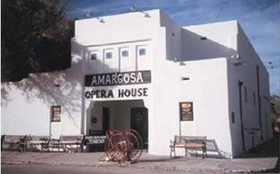 the
Amargosa Opera House offers visitors a musical performance by renowned
ballet star Marta Becket. It is another one of those incredible desert
incongruities. In 1967, Marta Becket, a classical dancer, stopped here
to fix a flat tire and left with a dream. She leased the rundown theater
for $45 a month, renamed it the Amargosa Opera House, and with her husband
began fixing it up. Her first show drew 12 customers; on some evenings,
that first year, nobody at all came. So Becket painted an audience on
the walls and kept on performing. Try to time your visit with a performance
(reservations are necessary. 760 852 4441).
the
Amargosa Opera House offers visitors a musical performance by renowned
ballet star Marta Becket. It is another one of those incredible desert
incongruities. In 1967, Marta Becket, a classical dancer, stopped here
to fix a flat tire and left with a dream. She leased the rundown theater
for $45 a month, renamed it the Amargosa Opera House, and with her husband
began fixing it up. Her first show drew 12 customers; on some evenings,
that first year, nobody at all came. So Becket painted an audience on
the walls and kept on performing. Try to time your visit with a performance
(reservations are necessary. 760 852 4441).
From here, head back toward Route 160, Pahrump and Las Vegas filled with a new vision of Death Valley and deserts in general. Death Valley National Park, established in 1994, comprises 3,000 square miles (over 3.3 million acres) of widely differing topography, and is now the largest national park in the coterminous United States.
"Death Valley" was the term the first emigrants used after
their fateful
crossing in the winter of 1849. Indians knew this area as Tomesha, "Ground
Afire." The Valley generally receives about 1.8 inches of rainfall
per year, but weather conditions vary greatly throughout the region, primarily
with elevation.
The hottest day on record in the United States was recorded at Furnace
Creek in 1913 when the temperature peaked at 134°F. On a normal summer
day, when air temperature is a brisk 120°, ground temperature on the
valley floor can be 200 °F. The months between October and March are
uniformly cool and pleasant, with highs ranging between 68 and 80 degrees.
Death Valley is not a name anyone in the tourist business would pick;
but some tourists leave Death Valley disappointed if they have not experienced
temperatures of 120° or higher! You will arrive back in Las Vegas
with your appetite whetted for more desert adventures.
Start planning your next trip into Death Valley; there is much more to
see and do: visit Scotty's Castle, scramble down Ubehebe Crater, drive
through Hell's Gate and more. Or, make a day of it in Nevada's Red Rock
Canyon or the Valley of Fire State Park. Never again will you conjure
up a mental picture of a vast wasteland with blowing sand and bones whitening
in the unmerciful sun when you hear the word desert.
Search the Web for related information on Death Valley
Home | North
America | South & Central America | Europe
Asia & Middle East | Africa
| Oceania | Favorite
Accommodations
Travel Images Blog
| Preferred
Accommodations Blog
Travel Blog | Columns
| About Sandra | Contact
Sandra | Site Map
Copyright
© 2002-2007 Sandra Scott. ALL RIGHTS RESERVED
Site
designed and created by C.F. Howley
Make your travel plans here.
![]()
![]()
![]()